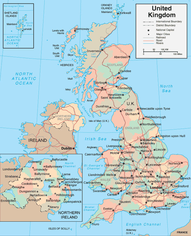
United Kingdom Map
United Kingdom Map
Navigate United Kingdom map, United Kingdom country map, satellite images of United Kingdom, United Kingdom largest cities, towns maps, political map of United Kingdom, driving directions, physical, atlas and traffic maps.
Click for Content Detail »
Find desired maps by entering country, city, town, region or village names regarding under search criteria. On upper left Map of United Kingdom (+) beside zoom in and (-) sign to to zoom out via the links you can visit. United Kingdom Map move the mouse over it via (left click) and clicking the image you can drag. Right upper Map, Satellite, Terrain icons via the map view, satellite, hybrid and terrain map can be switch between images.

United Kingdom City Maps
» Aberdeen » Belfast » Birmingham » Blackburn » Bolton » Bradford » Bristol » Cardiff » Coventry » Derby » Edinburgh » Glasgow » Huddersfield » Ipswich » Kingston Upon Hull » Leeds » Leicester » Liverpool » London » Manchester » Middlesbrough » Newcastle » Northampton » Norwich » Oxford » Peterborough » Plymouth » Portsmouth » Reading » Sheffield » Southampton » Stoke on Trent » Sunderland » Swansea » Walsall » Watford » West Bromwich » Wolverhampton » York » Homeland » Homeland » Homeland » Homeland Park » Nottingham » Dudley » Luton » Preston » Milton Keynes » Bournemouth » Southend on Sea » Swindon » Dundee » Poole » Blackpool » Telford » Stockport » Brighton » Slough » Gloucester » Rotherham » Newport » Cambridge » Exeter » Eastbourne » Sutton Coldfield » Colchester » Oldham » St Helens » Woking » Crawley » Chelmsford » Basildon » Cheltenham » Gillingham » Worthing » Rochdale » Solihull » Worcester » Derry » Southport » Basingstoke » Bath » Maidstone » Harlow » Grimsby » Darlington » Hartlepool » Lincoln » Hastings » Birkenhead » Halifax » Hemel Hempstead » South Shields » Bedford » St Albans » Stevenage » Wigan » Warrington » Chester » Stockton on Tees » Gateshead » Weston super Mare » High Wycombe » Wakefield » Redditch » Newcastle under Lyme » Paisley » East Kilbride » Chatham » Burnley » Salford » Scunthorpe » Hove » Carlisle » Tamworth » Barnsley » Harrogate » Lisburn » Bracknell » Nuneaton » Chesterfield » Mansfield » Guildford » Gosport » Aylesbury » Lowestoft » Doncaster » Crewe » Shrewsbury » Ellesmere Port » Cannock » Grays » Stafford » Waterlooville » Torquay » Kingswood » Bognor Regis » Newtownabbey » Rugby » Royal Leamington Spa » Bury » Royal Tunbridge Wells » Runcorn » Rhondda » Bootle » Ashford » Maidenhead » Wallasey » Margate » Bangor » Taunton » Aldershot » Great Yarmouth » Farnborough » Bebington » Dartford » Hereford » Fareham » Littlehampton » Widnes » Stourbridge » Kidderminster » Cheshunt » Halesowen » Loughborough » Sale » Dewsbury » Morley » Washington UK » Gravesend » Eastleigh » Crosby » Clacton on Sea » Kettering » Livingston » Dunstable » Macclesfield » Barry » StainesRelated United Kingdom Maps and United Kingdom Satellite Images
map of uk
where is united kingdom in the world
stonehenge wiltshire united kingdom 2500 bc
british empire united kingdom map
uk topographic map
english speaking world map
united kingdom foreign born population by country map
british citizens living overseas by country 2006 map
england map
england map
map of united kingdom
map of england
map of United Kingdom
map of united kingdom
map united kingdom
satellite image of united kingdom
topographic map of united kingdom
uk map
uk counties map
uk eu map
uk map
uk physical map
uk universities map
united kingdom map
united kingdom cities map
united kingdom europe map
united kingdom geographic map
united kingdom greenhouse map
united kingdom map
united kingdom postcode map
united kingdom rail map
united kingdom solar radiation map
United Kingdom Earth Map
Click for Google Map »
Where on World Map
Click for Direction »
Road Map and Direction
Click for Street View »
Click for comments and questions »
Please feel free share your comments and questions :
Please feel free share your comments and questions :
